Microsoft shares new street view system

Updated Emily Banks 0 Tallied Votes 735 Views Share

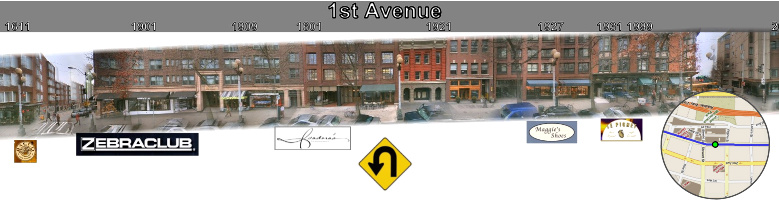
Microsoft has revealed a new, more comprehensive street view system, dubbed Street Slide, set to compete with Google's Street View and Bing Maps' Streetside. According to Microsoft , the Google and Bing systems only allow users to view city streets via an immersive 360-degree panorama or "bubble." And users can travel down the street only by jumping from one bubble to another, creating pixelated images of close-ups and making it impossible to view a whole city block at one time. But Street Slide uses what Microsoft calls "multi-perspective strip panoramas," combining "bubbles" with panoramas.

"We demonstrate a seamless transition between bubbles and multi-perspective panoramas. We also present a dynamic construction of the panoramas which overcomes many of the limitations of previous systems. As the user slides sideways, the multi-perspective panorama is constructed and rendered dynamically to simulate either a perspective or hyper-perspective view," Microsoft posted on its research Web page .

"Our goal in constructing the Street Slide application is to provide a seamless means to explore the details of individual bubbles while also being able to navigate efficiently and intuitively along the streets," Microsoft's researchers wrote. "Our solution consists of a hybrid between a traditional pan and zoom interface within a bubble for small fields of view and a multi-perspective panorama for wider views of the street side. As the user’s field of view within a single bubble widens to a threshold, we lock the apparent field of view and instead simulate dollying backwards by combining imagery from nearby bubbles to form a multi-perspective panorama."
[youtube]K-_T949uSwU[/youtube]A user study found that Street Slide provides a better visual searching experience than Google Street View and Bing Maps Streetside, according to Microsoft. Users were able to find nearby landmarks more quickly than the Google and Bing systems. And while some test subjects found Street Slide confusing initially, they found it easier after a minute, compared to finding Google Street View easy at first and later becoming frustrated by the system, according to Microsoft.

The new system also opens the door to online advertising in the spaces above and below the street image, which also explicitly displays the street name and address numbers. By clicking on the address number, users can zoom into the building at that address.

Microsoft has processed some 2,400 panoramas that cover four kilometers on six streets and eight intersections and the company has begun to implement the new system on a mobile platform.
Dani AI

Generated

This thread captures the key reactions: opened the topic, liked the more intuitive navigation, flagged the inevitable "funny" street snaps, and reminds us that established systems set user expectations. Below are practical, evergreen notes for anyone building, evaluating, or comparing hybrid street‑level viewers.

At a high level the hybrid approach composes imagery from multiple nearby camera positions into a continuous lateral strip rather than relying solely on isolated 360° nodes. That reduces the jumpy "node-to-node" feel and gives more continuous context, but it also changes projection geometry: moving objects can warp, occlusions are harder to resolve, and typical pinhole assumptions break down. Expect tradeoffs between continuity and geometric fidelity.

Practical checklist and guidance:

  • Capture: calibrate lenses, synchronize GPS+IMU, and keep high overlap between frames to reduce ghosting.
  • Preprocess: correct lens distortion, normalize exposure/color, and consider per-frame depth estimation to handle occlusions.
  • Client rendering: stream tiled imagery, use GPU compositing (WebGL) and progressive LOD so phones stay responsive; prefetch adjacent strips to hide load pauses.
  • Discoverability & accessibility: publish textual addresses and POI metadata (structured markup), add keyboard controls and ARIA labels so content isn’t trapped inside images.
  • Privacy & ops: implement face/plate blurring, simple opt‑out/DMCA flows, and clear moderation for sensitive captures.

UX evaluation and quick fixes:

  • Measure time‑to‑find, success rate, and subjective learning curve with within‑subject tests.
  • If seams or ghosting appear, increase overlap and enable per‑image white‑balance; use feathered seams instead of hard cuts; reduce resolution on distant tiles for performance.

These steps help turn a promising research demo into a practical, searchable, and privacy‑aware product that meets both user expectations and SEO/accessibility needs.

Mapper99 0 Light Poster

Very cool! I wonder if funny situations like these will start to show up on blogs like this: http://www.streetviewfunny.com/

PierlucSS 52 Junior Poster

Wow, this is pretty cool, and in my opinion, way more user-friendly than Google Street View.

fast5 0 Newbie Poster

haha that is seem like google street view...
but nice try microsoft, i think google street view more better, :D

Be a part of the DaniWeb community

We're a friendly, industry-focused community of developers, IT pros, digital marketers, and technology enthusiasts meeting, networking, learning, and sharing knowledge.